Latest Photos

Flowers in Pakistan. Ratti Gali Lake, Neelum Valley, AJK, Pakistan Ratti Gali Lake, Neelum Valley, AJK, Pakistan Sindh River Kund Malir, Balochistan Landsowne Bridge, Sukkur Kalashi Girls Chitral Kalashi Girls Chitral A kid in Neelum Valley Chittori, Cemetery of Talpur family, Mirpur Khas. Sindh River Ratti Gali Lake, Neelum Valley, AJK, Pakistan
Search this blog..

Top Stories of the week

ERROR - UNABLE TO LOAD CONTROL : /controls/linkexchange/plug_linkexchange.ascx limit=9;The file '/controls/linkexchange/plug_linkexchange.ascx' does not exist.

Bhambore, Sindh

Posted in : Sindh, Thatta, Archaeological Sites

(added few years ago!)

Bhambore is an interesting archeological site at a distance of 64 km from Karachi while travelling on National Highway.

Originally, it was a sea port named Debal, a thriving Hindu stronghold ruled by Raja Dahir in 712 AD and before.
 
 
Muhammad Bin Qasim, a young man of barely 17 years, who came with a Muslim army, invaded Debal and defeated Raja Dahir and his forces. . From here, Muhammad Bin Qasim made inroads to interior Sind and onwards to Multan and spread the torch of Islam. 
The city remained intact till 13th century and afterwards was destroyed due to changing course of River Indus. Now there are ruins of the city & a Museum where on display are many pieces of earthwork, figurines and pottery which were in use of the people who once lived here. 
 
Location:
View Larger Map 


Read the rest of this entry »

(added few years ago!) / 4972 views

Badshahi Mosque, Lahore

Posted in : Punjab, Lahore, Tourist Attractions, Mosques / Tombs

(added few years ago!)

Mughal Emperor Aurangzeb Alamgir built the Badshahi mosque during his rule from 1658 to 1707.

It is one of the many significant architectural monuments/landmark in Lahore.
The mosque is a major tourist attraction along with Lahore fort which is adjacent to Badshahi Mosque
The prominence of the mosque in the imperial vision was such that it was constructed just a few hundred meters to the west of Lahore Fort.
A special gate facing the mosque was added to the fort and designated the Alamgiri gate.
 

The mosque construction is a a beautiful mixture of Islamic, Persian, Central Asian, and Indian architecture. Its foundation and structure is built with bricks and compacted clay, then covered with red sand stone tiles brought from stone quarry near Jaipur in Rajasthan. The main prayer hall is decorated with fresco work, stucco tracery, and inlay marble. The exterior is decorated with stone carving and inlay marble on red sand stone. Three beautiful and large domes as well as the tops of minarets are covered with Wight marble. Minarets on all four corners are 53.75 meters in height and 20 meters in circumference.

Location :
View Larger Map


Read the rest of this entry »

(added few years ago!) / 4356 views

Hingol National Park, Makran Balochistan

Posted in : Balochistan, Mountains / Peaks / Passes, National Parks, Temples / Churches / Gurdwaras

(added few years ago!)

Hingol National Park covered area around 1,650 sq km is the largest National Park of Pakistan.

It lies on Makran coast in Balochistan and is approximately 190 km from Karachi.
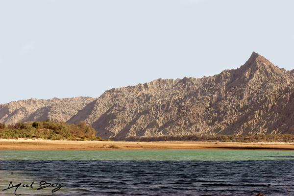
 

Some parts of three districts of Balochistan province namely Lasbela    Gwadar and Awaran are covered in this Park.
Hingol River passes through the length of  the park which supports a significant diversity of bird and fish species
At least 35 species of mammals, 65 species of amphibians and reptiles and 185 species of birds have been documented in the park.
Among these wild Sindh Ibex, Afghan Urial, Chinkara Gazelle are prominent.
Park Facts:
Geographical Location: 25*30'N-65*30'E
Physical Location: Makran coast, Baluchistan province.
Approximately 190 km west of Karachi
Total Area: 610, 043 hectares
Date Established: 1988 and 1997 (includes Dhrun Wildlife Sanctuary)
Best Time to Visit: Mid October to November and December to mid March
 
Location:
View Larger Map

Read the rest of this entry »

(added few years ago!) / 5299 views

Khunjerab Pass, KKH

Posted in : Gilgit-Baltistan, Mountains / Peaks / Passes, National Parks

(added few years ago!)

Khunjerab Pass is the highest paved international border crossing in the world and the highest point on the Highway.

At a height of 15,397 feet, it connects Gilgit–Baltistan region of Pakistan to Xinjiang region of China.

The long, relatively flat pass is often snow-covered during the winter season and therefore is generally closed from November 30 to May 1.

At present due to formation of Atabad Lake in Hunza Region, which has blocked the Karakorum Highway near Gulmit, the pass is not road able and one has to cross the lake by boat to move further ahead into china from Pakistan.
 
Location:
View Larger Map

Read the rest of this entry »

(added few years ago!) / 3871 views

Phandar Lake, Gilgit

Posted in : Gilgit-Baltistan, Gilgit, Hotels, Lakes

(added few years ago!)

At location: 36°10'13"N 72°55'4"E Phandar Lake in Phandar Valley along Gilgit River is famous for its trout fishing.

It stands beautiful form of nature where crystal green water, sand, green grass, straight trees, rocky mountains all layer up till the snowy mountains in the background


The place is easily accessible from Gilgit via a metallic road.
There is a PTDC Motel along with few other budgeted motels for tourists to enjoy this serene beauty.
 
Location:
View Larger Map

Read the rest of this entry »

(added few years ago!) / 4841 views

Eagle's Nest, Hunza

Posted in : Gilgit-Baltistan, Hunza Valley, Hotels, Gilgit-Baltistan, Hill Stations

(added few years ago!)

Hunza valley has the best view point “Eagle’s Nest” of Dulkar Village.

This place is easily accessible from Karimabad Town by a 6 Km metal road.


Hunza Eagle's Nest offers the World's only view point that offers spectaculatr views 11 peaks, all 6,000 - 7,788 Meters high.
The most famous are Rakaposhi, Ultar Peak, Golden Peak, Diran Peak & Lady Finger.
A 3 + star hotel with spacious rooms, restaurant, fruit garden & a traditional hunza house adds glamour to this place.
 
Location:
View Larger Map

Read the rest of this entry »

(added few years ago!) / 5395 views

Satpara Lake, Skardu

Posted in : Gilgit-Baltistan, Skardu, Tourist Attractions, Lakes

(added few years ago!)

The Satpara Dam development project on the Satpara Lake was inaugurated in 2002 and expected to be completed soon. It is 7 km away from Skardu city and its altitude is 8,700 feet (2,700 m) moreover it will also pond the water about 90,000 acre feet (110,000,000 m3). The main source of water is melting ice of the Deosai plains during the summer season.


It is a multipurpose project, which will produce 13 Megawatts hydro generation, irrigate 15,000 acres (61 km2) of land and also provide 13 cusecis drinking water daily to Skardu city.
Satpara Lake
Satpara Lake is Skardu Valley's main lake. In 2002, the Government of Pakistan decided to build a dam on the Satpara Lake allocating $10 million to the Satpara Dam project, two years later in 2004. Progress on the project has, however, been slow. Satpara Lake is 6 miles (9.7 km) from Skardu. Satpara Lake is one of the largest fresh water lakes in the countryside offering trout fishing, and row boating. This lake is also the source of Skardu's drinking water.
 
Location :
View Larger Map

Read the rest of this entry »

(added few years ago!) / 3662 views

Taung Tombs, Kirthar National Park

Posted in : Sindh, Archaeological Sites, Mosques / Tombs

(added few years ago!)

The tombs at Taung near Karchaat are quite similar to the ones which can be seen at Chaukandi (near Karachi) and Makli (near Thatta).

Their significance is their preservance. They are in excellent condition, although nobody knows when these were built or which civilization lived there.

The carvings on theses tombs depicts their gender, with one having weapons on it are of males & others having ornaments are of females. 
 
Location:
View Larger Map

Read the rest of this entry »

(added few years ago!) / 7187 views

Baltit Fort - Karimabad

Posted in : Gilgit-Baltistan, Hunza Valley, Forts / Palaces

(added few years ago!)

Baltit Fort or Balti Fort is an ancient fort in the Hunza valley in the Northern Areas of Pakistan.

In former times survival of the feudal regimes of Hunza was ensured by the impressive Baltit fort, that sit on top of Karimabad. The foundations of the fort are said to date back around 700 years, but there have been rebuilds and alterations over the centuries. In the 16th century the Thum married a princess from Baltistan who brought master Balti craftsmen to renovate the building as part of her dowry. The architectural style is a clear indication of Tibetan influence in Baltistan at the time.
 
 
The Mirs of Hunza abandoned the fort in 1945, and moved to a new palace down the hill. The fort started to decay and there was concern that it might possibly fall into ruin. Following a survey by the Royal Geographical Society of London, a restoration programme was initiated and supported by the Aga Khan Trust for Culture Historic Cities Support Programme. The programme was completed in 1996 and the fort is now a museum run by the Baltit Heritage Trust.
 
The rich beauty of Baltit Fort can be traced to over seven hundred 700 years ago. Ayasho II, Tham / Mir of Hunza in the early 15th fifteenth century married Princess Shah Khatoon (Sha Qhatun) from Baltistan (In Moghul history Baltistan is called Tibet Khurd mean, little Tibet), and was the first to modify the face of Altit and, subsequently Baltit Fort. Baltistan meaning land of Balti people had a very strong cultural and ethnical relation with the Ladakh territory of India then. Consequently, the structure of Baltit Fort was influenced by the Ladakhi / Tibetan architecture, with some resemblance to the Potala Palace in Lhasa. Then additions, renovations and changes to the building were being made through the centuries by the long line of rulers of the Hunza that followed.
 
Location :
View Larger Map 


Read the rest of this entry »

(added few years ago!) / 4365 views

Karimabad - Hunza

Posted in : Gilgit-Baltistan, Hunza Valley

(added few years ago!)

Karimabad is the capital of Hunza in Gilgit-Baltistan, northern Pakistan. Karimabad is also known as Baltit. It is named after Prince Karim Aga Khan, the spiritual head of Shia Ismaili Nizari community. The Guardian ranked it as the 12th Best Tourist Site in Pakistan.

Karimabad is the main tourist`s attraction in the Hunza valley. It is surrounded by high peaks like Ultar, Hunza Dome, Lady Finger while it offers inspiring views of Diran Nagar and Rakaposhi Nagar. A view of sunrise and sunset is out of the world, especially from a high point above Karimabad, called as Duiker. 

A walk through the villages with terraced fields is a pleasant experience and one might get an invitation at a local house for a cup of tea. The bazaar of Karimabad is colorful and interesting for the shoppers. The main items of interest include: local handicrafts, souvenirs, hand woven rugs, embroidered caps, Old Settlement of Ganesh shawls, hand woven cloth known as pattu or Patti and gemstones etc. A day hike through the narrow gorge of Ultar, jumping over loose boulders is a demanding walk, however reaching the snout of Ultar Glacier and the view of the valley by jeeps offers interesting view of sweeping and crevassed glaciers. Ganesh is a small but fast developing village on the KKH. A visit to Ganesh village is interesting with its famous rock inscriptions known as sacred rocks of Ganesh.
 
Location :
View Larger Map


Read the rest of this entry »

(added few years ago!) / 6952 views