Latest Photos

Head Marala - Sialkot Daokhan Forest Rest House, Leepa Valley, Azad Jammu & Kashmir, Pakistan Pine tree. Kalar Kahar lake Culture Of Pakistan ! PAF Museum, Karachi Ratti Gali Lake, Neelum Valley, AJK, Pakistan Ratti Gali Lake, Neelum Valley, AJK, Pakistan Birds of Sindh. Bulbul & more PAF Museum Karachi Head Marala - Sialkot
Search this blog..

Top Stories of the week

ERROR - UNABLE TO LOAD CONTROL : /controls/linkexchange/plug_linkexchange.ascx limit=9;The file '/controls/linkexchange/plug_linkexchange.ascx' does not exist.

Haleji Lake

Posted in : Sindh, Lakes

(added few years ago!)


Haleji Lake
Originally Haleji Lake was a very small lake. During World War II the then British Government of Sind decided to increase the capacity of this lake by having a feeder canal from River Sindh. This lake supplies water to Karachi. During War time thousands of American and British Troops were stationed in Karachi. The lake work was taken on War Footing and was completed within 24 months. 


Haleji Lake is 85kms form Karachi.
 
 
Location:
 

Read the rest of this entry »

(added few years ago!) / 2115 views

Chaukhandi Tombs

Posted in : Sindh, Karachi, Archaeological Sites

(added few years ago!)

The Chaukhandi tombs are situated 29 km east of Karachi on N-5 National Highway near Landhi Town in Pakistan. The Chaukhandi tombs are remarkable for the elaborate and exquisite stone carving.

The style of architecture is typical only to the region of Sindh, and unique in that it is found nowhere else in the Islamic world. Generally, the elements are attributed to Jokhio (also spelt Jokhiya) also known as the family graveyard of Jokhio tribe, some people of Baluch tribe also buried were built between the 15th and 18th centuries.


This type of graveyard, in Sindh and Baluchistan, is unique with their orientation from south to north. These graves are constructed in buff sandstone. Their carved decoration presents exquisite craftsmanship. These graves are constructed either as single graves or as groups of up to eight graves raised on a common platform.
 
Their primary sarcophagus has six vertical slabs, with two long slabs standing on each side of the grave covering the length of the body and the remaining two vertical slabs covering the head and foot side. These six slabs are covered by a second sarcophagus consisting of six more vertical slabs similar but in size giving the grave a pyramid shape. This upper (second sarcophagus) is further covered with four or five horizontal slabs and the topmost (third) sarcophagus is set vertically with its northern end carved into a knob known as a crown or a turban. These tombs are embellished, besides with geometrical designs and motifs, with figural representations such as mounted horsemen, hunting scenes, arms, jewellery etc..
 
19th century
The earliest passing reference about Chaukhandi tombs (aka Jokundee) in the Western world is available in a letter which J. Macleod had addressed to H. B. E. Frere in 1851. The tombs, however, were given serious attention by H. D. Baskerville, Assistant Collectorof Thatta in Karachi district in 1917. The tombs near Landhi were brought with the pale of the Ancient Monuments Preservation Act, 1904 in the year 1922.
 
Location:
 

Read the rest of this entry »

(added few years ago!) / 3607 views

Hanna Lake, Urak - Quetta

Posted in : Balochistan, Quetta, Lakes

(added few years ago!)

Hanna Lake is a lake near Quetta city in Pakistan and is one of the main attractions in the city and a reservoir was Constructed by the British Empire.

In 1894, a small action dam Surrpull (Red Bridge) was constructed on main Urak road for converting of water into Hanna Lake coming from the Zarghoon Mountains range, of streams, snow melting and rains through main channel. This channel nowadays needs repairs and is wasting water and recently the water level is deadly low, up to three feet, and thousands of fish are in danger. There is also a water channel which was constructed the same time by the British to convert the snow and rain water near spin kaarez coming from Murdar mount to surrpull for filling of water in this lake. This channel was destroyed by the heavy flood in 1976 and still not constructed and all the snow and rain water is going waste till now and resultant the Hanna Lake was fully dried in 1999 to January 2005. If Hanna Lake Development Authority (HLDA) the custodians of Hanna Lake did not perform any action to bring water through surrpull the lake will be soon dry again. The lake is located a little short of the place where the Urak Valley begins and 14 km from Quetta. 


The beautiful Hanna Lake was built in the time of British Empire in 1894. Golden fish in the lake come swimming right up to the edge of the lake. There is a lakeside restaurant with picnic tables shaded by pine trees. At one end, the irrigation dam rises out of the depths like battlements of a fort, and on the eastern part the well known Hayat Durrani Water Sports Academy (HDWSA) the only rowing, canoeing, kayaking and sailing training center in Balochistan Province.
 
Kayaking in front of the historical Bridge wall of Hanna Lake constructed by Great Britain in 1894.
Hanna Lake is very attractive for holidaymakers, and is crowded with hikers and campers in holidays. You can hire a boat and paddle on the lake and round the island in the middle.
The HLDA / HDWSA and Merck has planted various trees for the beautification and protection of environment in Hanna Lake Mountains.
 
Location:
 

Read the rest of this entry »

(added few years ago!) / 4772 views

Banjosa Lake

Posted in : Azad Kashmir, Banjosa, Hill Stations, Lakes

(added few years ago!)

Banjosa Lake is Situated 20 kilometers from Rawalakot, Azad Kashmir,  at an altitude of 1981 meters. Its scenic beauty and impressive surrounding is compelling and attracts tourists to reach here to enjoy the nature for a possible comeback. Amidst the captivating beauty of Banjosa the artificial lake reflects the dense forest standing along the surrounding of the resting calm waters of Banjosa lake.

The nearby worth seeing areas of Banjosa are Jandali, Hussain kot and Devi gali which can't be simply bypassed for a pleasure trip. The distance parting the destinations from Banjosa are 3 km, 4kms and 12 km respectively. These places portray rich inherent natural beauty encompassing all others while awaiting visitors for a comfortable stay. Also, Ghorimar is situated 20 km from Khaigala awaiting ones arrival to explore the fascinating beauty over-looking the sub-valley of Rawalakot and Bagh.

Location:


View Larger Map 


Read the rest of this entry »

(added few years ago!) / 3484 views

Kallar Kahar Lake

Posted in : Punjab, Lakes

(added few years ago!)

Kallar Kahar is a union council and subdivision of Chakwal District in Punjab, Pakistan. It is a tourist destination located 25 kilometres southwest of Chakwal along the motorway. It is notable for its natural gardens, peacocks and a saltwater lake. It is 125 km away from Rawalpindi.

 
The Katasraj temples are situated in Choa Saidanshah tehsil (CSS), in 1981 a project was started named as Pak German Project (PGP). There also a degree and college for Mines diploma. There is a cadet college in Kallar Kahar named Cadet College Kallar Kahar, functional since 1998; it produces a variety of professionals, including army cadets, doctors and engineers.


Lying 30 miles southwest of Chakwal on the Chakwal-Sargodha road, Kallar Kahar is known for its peacocks, for its freshwater lake, and for the Takht-e-Babri, a flat stage built of stone by emperor Babar to address his army while coming down from Kabul in the quest of the crown of Delhi. During his stay at Kallar Kahar, Babar also planted a garden, which still exists, called the Bagh-e-Safa. In his memoirs, the Tuzk-e-Babri, Babar described Kallar Kahar as a "charming place with good air" and natural beauty.
 
Location.


Read the rest of this entry »

(added few years ago!) / 6734 views

Rohtas Fort

Posted in : Punjab, Forts / Palaces

(added few years ago!)

Rohtas Fort is a garrison fort built by the great Afghan king Sher Shah Suri. This fort is about 4 km in circumference and the first example of the successful amalgamation of Pashtun and Hindu architecture in the Indian Subcontinent.


Sher Shah Suri named Qila Rohtas after the famous Rohtasgarh Fort in Shahabad district near Baharkunda, Bihar which he captured from the Raja of Rohtas Hari Krishan Rai in 1539. 
 
Rohtasgarh is situated on the upper course of the river Son, 20 37’ N and 85 33’E. It was built by Harish Chandra of the Solar dynasty and was named after his son Rohitasva after whom the fort (Rohtasgarh) was named.
 
Sher Shah constructed Qila Rohtas to block Emperor Humayun's return to India after defeating him in the Battle of Kanauj. This fort lies on the old GT road between the North (Afghanistan) to the Plains of Punjab. It blocked the way from Peshawar to Lahore. The other reason was to suppress the local tribe of this region Potohar called Gakhars who were allies of Humayun and refused their allegiance to Sher Shah Suri. The Emperor instructed the local Janjua Rajput tribe to help construct the fort to crush the Gakhars when the latter became openly defiant and persecuting labourers who attended the construction.
The Fort was built by Todar Mal under orders of Sher Shah.
 
Location
Qila Rohtas is situated in a gorge approximately 16 km NW of Jhelum and 7 km from Dina. It was constructed on a hillock where the tiny Kahan river meets another rainy stream called Parnal Khas and turns east towards Tilla Jogian Range. The fort is about 300 feet (91 m) above its surroundings. It is 2660 feet (818 m) above sea level and covers an area of 12.63 acres 


Read the rest of this entry »

(added few years ago!) / 4044 views

Mohenjo-Daro

Posted in : Sindh, Archaeological Sites

(added few years ago!)

Mohenjo-Daro, situated in the province of Sindh, Pakistan, was one of the largest city-settlements of the Indus Valley Civilization. Built around 2600 BC, it was one of the world's earliest major urban settlements, existing at the same time as the civilizations of ancient Egypt, Mesopotamia, and Crete. The archaeological ruins of the city are designated a UNESCO World Heritage Site.


Rediscovery and excavation
 
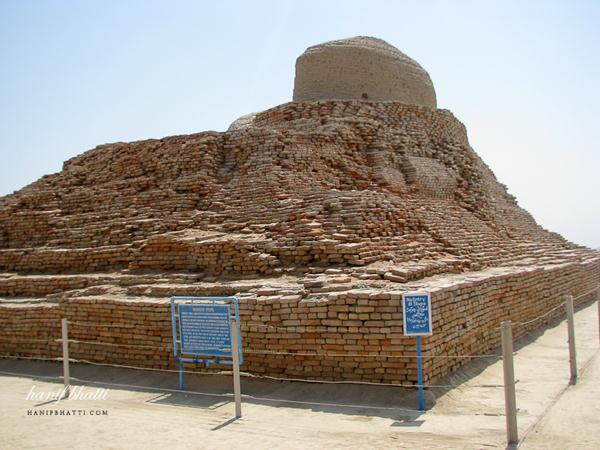
Mohenjo-daro was built around 2600 BC and abandoned around 1800 BC. The ruins of the city were discovered in 1922 by Rakhaldas Bandyopadhyay, an officer of the Archaeological Survey of India. He was led to the mound by a Buddhist monk, who believed it to be a stupa. In the 1930s, massive excavations were conducted under the leadership of John Marshall, K. N. Dikshit, Ernest Mackay, and others. John Marshall's car, which was used by the site directors, is now on display in the Mohenjo-daro museum. Further excavations were carried out in 1945 by Ahmad Hasan Dani and Mortimer Wheeler.
 
The last major excavations were conducted in 1964-65 by Dr. George F. Dales. After this date, excavations were banned due to weathering damage to the exposed structures, and the only projects allowed at the site since have been salvage excavations, surface surveys and conservation projects. However, in the 1980s, teams of German and Italian survey groups, led by Dr. Michael Jansen and Dr. Maurizio Tosi, used less invasive archeological techniques such as architectural documentation, surface surveys, surface scraping and probing to determine further clues about the ancient civilization.
 
Location
 
Mohenjo-daro is located 25 km southwest of Larkana in Sindh, Pakistan, on a Pleistocene ridge in the middle of the flood plain of the Indus River Valley. The ridge is now buried by the flooding of the plains, but was prominent during the time of the Indus Valley Civilization, alloweing the city to stand above the surrounding plain. The site occupies a central position between the Indus River valley on the west and the Ghaggar-Hakra river on the east. The Indus still flows to the east of the site, but the Ghaggar-Hakra riverbed is now dry.
 

Read the rest of this entry »

(added few years ago!) / 8827 views

Khewra Salt Mines

Posted in : Punjab, Museums / Monuments / Others

(added few years ago!)

Khewra Salt Mines is a salt mine located in Khewra, Jhelum District, Punjab in Pakistan, about 160 kilometres (99 mi) from Islamabad and 260 kilometres (160 mi) from Lahore. It attracts up to 40,000 visitors per year and is the second largest salt mine in the world. Situated in the foothillsof the Salt Range, the Khewra Salt Mines are the oldest in the South Asia.


Salt has been mined at Khewra since 320 BC following discovery by Alexander's troops, in an underground area of about 110 square kilometres (42 sq mi). The main tunnel at ground level was developed by Dr. Warth in 1872 but has since been converted into a tourist resort. Khewra salt mine has estimated total of 220 million tonnes of rock salt deposits. The current production from the mine is 465,000 tons salt per annum.
 
The mine-head buildings have 19 stories, with 11 below ground. Only 50% salt is extracted and 50% is left as pillars to support the mountain. The salt-mine is 288 metres (945 ft) above sea level and extends around 730 metres (2,400 ft) inside the mountains from the mine-mouth. The cumulative length of all tunnels is more than 40 kilometres (25 mi).
Salt occurs in a Precambrian deposit in the form of an irregular dome-like structure. There are seven thick salt seams with a cumulative thickness of about 150 meters. At places the rock salt is 99% pure. Salt is transparent, white, pink, reddish to beef-color red. There are beautiful alternate bands of red and white color salt.
 
Discovery of the mine
 
It is said that when Alexander visited South Asia, coming across the Jhelum and Mianwali region, Khewra Salt Mines were discovered. The discovery of the mines, however, was not made by Alexander nor his "allies", but by his horse. It is stated that when Alexander's army stopped here for rest, the horses started licking the stones. One of his soldiers took notice of it and when he tasted the rock stone, it was salty thus leading to the discovery of the mines.
Afterwards this mine was wholly purchased by a local Raja and from that era to Independence of Pakistan this mine remained property of locally living Janjua Rajas who were sons of Raja Mal.
 
Location

Read the rest of this entry »

(added few years ago!) / 4541 views

Katasraj Temple.

Posted in : Punjab, Temples / Churches / Gurdwaras

(added few years ago!)

Katasraj Mandir is a Hindu mandir situated in Katas village in the Chakwal district of Punjab in Pakistan. Dedicated to Shiva, the temple has existed since the days of Mahabharata and the Pandava brothers spent a substantial part of their exile at the site. The Pakistan Government is considering nominating the temple complex for World Heritage Site status. It also proposes to spend about Rs 20 million in three phases for the restoration of the complex.


Most of the temples, located some 40 km from the modern city of Chakwal in the Potohar region of northern Punjab in Pakistan, were built during the reign of Hindu kings. These several temples were built around 900 years ago or more, although the earliest of the Katasraj temples dates back to the latter half of the 6th century A.D. Scholars believe that most of the temples were actually constructed when the Shahi kingdom, driven from Afghanistan when their ethnic cousin Mahmud of Ghanavi came to power, fled to the region and set up base there.
 
The mandir was abandoned by local Hindus when they migrated to East Punjab in 1947. It has always been the site of holy pilgrimage for people of various faiths. Even nowadays, worshippers from all faiths perform pilgrimages to the mandir every year and bathe in the sacred pool around which Katasraj is built. Santbetra Swami Ramananad Ji Maharaj used to visit this Lord Shiva Temple Once In Year. Betra was a village in Punch District. SantSahib ji had commitment with Raja Baldev Singh and never left this place . He was expired in 1950 and his samadhi is still in Nagithal ( Betra) & is popular as Nangapeer Ki Dargah.
 
Location
 
The Katasraj mandirs are located 40 kilometres from Chakwal District. It takes a little effort to reach Katasraj by road - one has to go off the M2 motorway - (Islamabad - Lahore) at the KallarKhar interchange. Then follow the road to Choa Saiden Shah for 24 km. just past the cement factory the road passes through the temple complex, with the major temple complex and the pond on the right. It is a picturesque sight.


Read the rest of this entry »

(added few years ago!) / 4556 views

Ranikot - Largest Fort in the World.

Posted in : Sindh, Forts / Palaces

(added few years ago!)

Ranikot Fort. Located about 30 km southwest of Sann, in the Kirthar Range, approximately 120 kms from Hyderabad Toll Plaza and 262 kms form Karachi. It is one of the largest forts in the world. 

It has an approximate diameter of 9 km. Its walls are on the average 6 meters high and are made of gypsum and lime cut sandstone and total circumference is about 29 km. While originally constructed for bow and arrow warfare it was later expanded to withstand firearms.


It is reputed to be the largest unexplored fort in the world. The purpose of its construction and the reason for the choice of its location are still unknown.
 
Fort Ranikot is located in Lakki Mountains of the Kirthar range to the west of the mighty River Indus at a distance of about 30 kilometers from the present day town of Sann. A mountainous ridge, Karo Takkar (Black Hill), running north to south, forms its western boundary and the 'Lundi Hills' forms its eastern boundary. Mohan Nai, a rain-stream enters the fort from its rarely used western 'Mohan Gate', where it is guarded by a small fortification, changes its name to 'Reni' or 'Rani Nai' or rain-stream and gives the fort its name. Ranikot is thus the 'fort of a rain stream' - Rani. It runs through it, tumbles in a series of turquoise pools to irrigate fields and leaves the fort from its most used 'Sann Gate' on the eastern side. It then travels about 33 kilometers more to enter the Lion River - Indus.
 
Location:
 

Read the rest of this entry »

(added few years ago!) / 3855 views